High Frequency Radar Surface Currents
HF radar systems utilize high frequency radio waves to measure the surface currents in the coastal ocean. Radar antennas (typically in pairs) are positioned on shore and can measure surface currents (the top 1-2 m of the water column) up to 200 km away with resolutions ranging from 500 m to 6 km depending on the radar frequency. The observations of the currents are usually 1-hour averages displayed in near real time. There are over 10 HF Radar systems presently operating throughout the Indian Ocean. For details Indian Coastal Ocean Radar Network (ICORN)
Objective
The main objectives of the ICORN are as follows
· Installation and maintenance of Coastal HF radar Network along the Indian coast including Islands.
· Measuring the sea surface currents and wave heights in near-real time along the coast up to 200km radially from each remote site (using varied frequency like 5 and 25 MHz).
· Transmission of data in near-real time to central servers at NIOT & INCOIS and then dissemination of data through INCOIS.
· Utilizing the data obtained from the HF radar network for better understanding of the coastal circulation and oceanographic/Engineering
This project was funded by Ministry of Earth Sciences through Ocean Observation Network (OON) Programme.

Move cursor over Text for map

Move cursor over Text for map

Move cursor over Text for map

Move cursor over Text for map

Move cursor over Text for map

Move cursor over Text for map

Move cursor over Text for map

Introduction
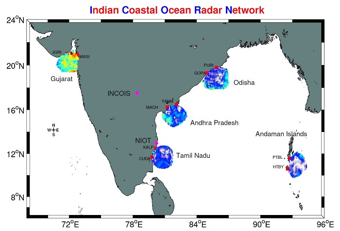
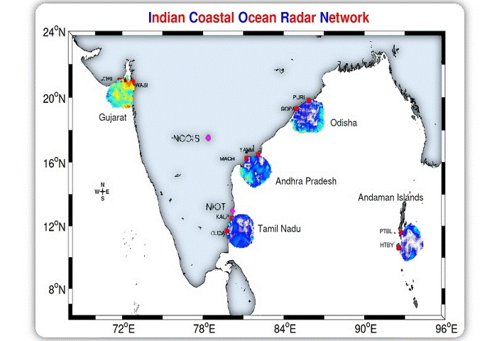
Indian Coastal Ocean Radar Network(ICORN) has been established along Indian coast under
NIOTs Tsunami Early Warning System project (TEWS) of Ministry of Earth
Sciences( MoES), Government of India. This Network
includes, ten remote HF Radar sites and two central sites viz. in NIOT, Chennai
and INCOIS, Hyderabad and are working continuously since the year 2010. During
the 12th five year plan, Coastal HF Radar systems were included in Ocean
Observation Network(OON) program of MoES, Administrative order(MoES/36/OOIS/OON/2012).
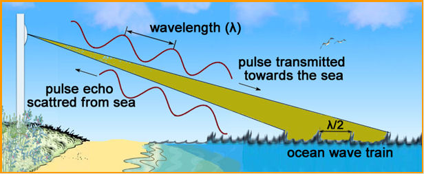
High Frequency (HF) Radar is a tool for synoptic on-line mapping of surface
current fields and the spatial distribution of the wave directional spectrum.
These instruments map surface currents in wide swaths of coastal waters up to
200 km offshore, 24 hours a day, and in all weather conditions. Data on coastal
currents will be useful to scientists to understand the ocean circulation along
the Indian coast, and to validate and improve the circulation models in bays
and estuaries. Assimilation of in situ data into model further enhances the
confidence of model forecasting. Scientists can use this data to study the
movement of juvenile fish and invertebrates, the influx of nutrients from the
deep ocean, and the outflow of pollutants from land. The near-real-time data
from HF Radar systems can be incorporated with Coast Guard in search-and-rescue
operations and oil spill models. This data can also be included in commercial
and recreational planning along beaches and ships navigating into ports. The
physics behind HF radar is relatively straightforwardBarrick
(1972a), Barrick (1972b), and Barrick,
Evans, and Weber (1977). A transmitter broadcasts electromagnetic waves usually
between 3MHz and 30MHz. These signals scatter off waves on the ocean surface.
If
a signal strikes an ocean wave that is exactly half of the broadcast signals
wavelength the ocean wave reflects the signal back to the transmitter. This
phenomenon is known as Bragg scattering. Since there are abundant waves of all
wavelengths present in the sea, there are always plenty of waves that fit this
criterion. In ideal conditions with ideal ocean waves, we can predict the
frequency of the returning signal based on the ocean waves size (its half the
wavelength of the transmitted signal) and its calculated phase speed (how
quickly it moves). Of course in the real world, ocean waves are never ideal,
but for these purposes, they are close enough. Surface currents, however, cause
these waves to move. This movement of the ocean waves shifts the frequency of
the returning signal due to the Doppler Effect. The frequency increases if the
current pulls the waves towards the transmitter and decreases if it pushes them
away. By measuring this Doppler shift, we can determine the speed of the
currents towards or away from the transmitter. To calculate the directions of
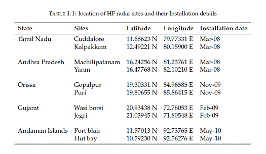
the currents, we need a second HF radar installation measuring the same currents from a different angle.ICORN
uses systems manufactured by CODAR Ocean Sensors. NIOT has created a
database of surface current information since 2009 along the Indian coast, and
some of the development has been done using these data. The installation
details of HF radar systems are depicted in Table 1.1 and all the sites are
working with 5MHz frequency.

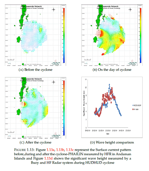
Observation of Phailin and Hudhud cyclone
Bay of Bengal is subjected to an average two tropical cyclone per year
and the coastal states are prone to inundation from these storms surges. Indian
coastal HFR networks could detect all the storm surges and tropical cyclones
events in its coverage.These networks have measured
High wave activities during major cyclones like Jal, Phailin and Hudhud
Manu et al. (2015) and corresponding observation are also made for ocean
surface currents Figure 1.13
Site Description
The selection of HF Radar sites depends on the frequency of operation, accessibility, and the objectives of the project. The Installation site should be free from any interference from the nearby frequency and metallic constructions. The position of receiver and transmitter antenna and the orientation with the shoreline should be as per the manual. The following section gives a description of all the 10 sites operated by NIOT.
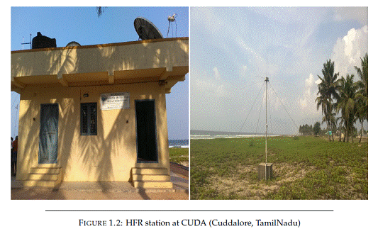
Cuddalore
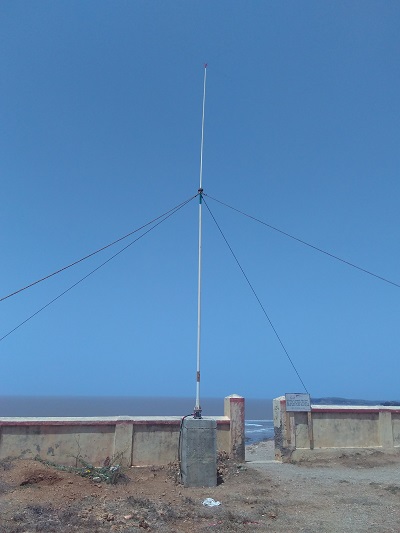
Cuddalore (CUDA) site is situated at Sothikuppam village Figure 1.2. which is 15 km away from the Cuddalore city of Tamilnadu. NIOT built a permanent concrete building to house the HF Radar systems. These site has been established back in March 2008 and in operational since then. Figure 1.2:
Kalpakkam
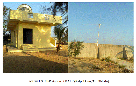
Kalpakkam (KALP) is situated 60km south of Chennai Figure 1.3 and these HF Radar systems are kept in Department of Atomic Energy township. This site also have a concrete building to keep the HF Radar systems.
Machilipatanam
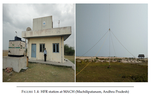
Machilipatanam (MACH) site is located at the Manginapudi Beach Figure 1.4 which is located at 11 km from Machilipatnam City in Krishna District and 85 km away from Vijayawada, Andhra Pradesh.
Yanam
Yanam(YANM) Site is located at coast of S Yanam Figure 1.5 village which is 15km away from the Amlapuram city of Andhra Pradesh.

Gopalpur
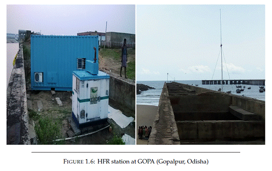
Gopalpur located at Gopalpur port Figure 1.6 in Ganjam district in Odisha. This site does not have permanent housing to keep HF Radar equipment, and a container is used for safe keeping.
Puri
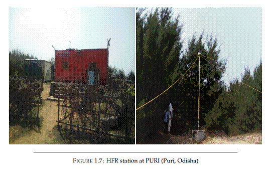
Puri(PURI) site is situated at the campus of well-known Shri Jagannath Sanskrit University Puri, Odisha Figure 1.7. Here also a container is used for keeping HF radar Equipments.
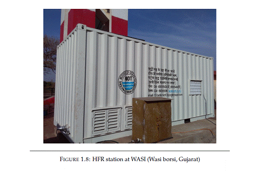
Wasi Borsi
Wasi borsi(WASI) Site is situated at Light house of village Borsi Machhiwad, in Gulf of khambhat Figure 1.8. The Lighthouse is about 20 Km west of Maroli Railway Station on Mumbai- Surat rail section, Gujarat.
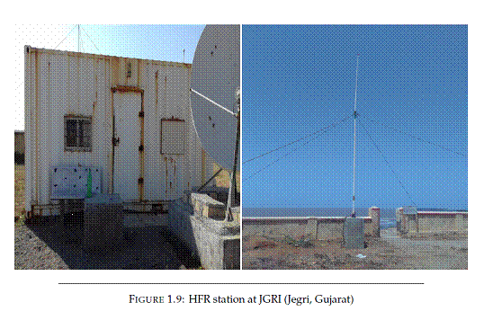
Jegri
Jegri (JGRI) site is located at Jegri Light house in Gulf of Khambhat Figure 1.9 which is 10 km away from the Mahuva city of Gujarat.
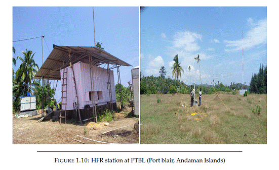
Port Blair
Port blair (PTBL) site is located along the coast of Rangachang village Figure 1.10 which is 20km away from Port Blair in Andaman & Nicobar Islands, India.
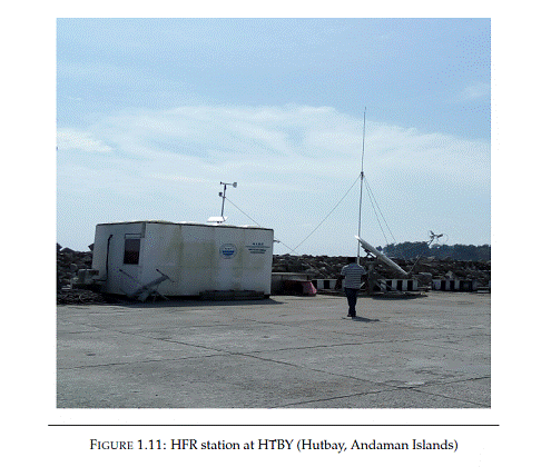
Hutbay
Hutbay (HTBY) site is located at Jetty, In Hutbay Island Figure 1.11 which is also called as little Andaman in Andaman & Nicobar Islands, India.
Coastal and Environmental Engineering
Coastal
and Environmental engineering (CEE) group focuses primarily on carrying out
research on the coastal processes, issues pertaining to engineering along the
coastline and coastal environmental quality. CEE has undertaken two major plan
projects viz., Shoreline management and Technical criteria atlas and a
component of Ocean observation, the HF Radar network under the XII plan. Major
projects of national importance undertaken by the group include seabed investigation
engineering and model studies for development of Gulf of Khambat
(Project Kalpasar) and Engineering feasibility and
Environmental Impact Assessment studies for marine coal handling facility off Cheyyur, Tamilnadu. The group has
the credit of working on World Bank projects viz., Waste load allocation and
assimilation capacity, State wide environmental action plan for various states,
development of guidelines for EIAs of infrastructure development; European
Union funded project on assessment of impacts of Tributlytin
(TBT) on multiple coastal uses, stabilisation of Haldia channel etc.
CEE
group is at the forefront of coastal related research and development compared
to traditional coastal engineering institutions due to the ability to integrate
field investigations, mathematical modeling studies, engineering solutions and
field execution tailored to site-specific requirements; all under one roof. The
group has primarily concentrated in evolving areas where research input is
higher. This can be clearly seen from the different types of projects handled
over the years which have resulted in accumulation of a spectrum of data bank
covering almost the entire coastline of the mainland and the islands of Andaman
and Nicobar and Lakshadweep. A large number of case studies have been
undertaken along the entire coastline for validation of model studies and
corroborated using field data. Significant contribution to society and industry
by the CEE group is by providing technical support for ports and harbours, erosion mitigation studies; fisheries harbour
development, navigation and allied activities.
Areas of expertise include detailed engineering designs for intakes and
outfalls, breakwaters, dredgeability and disposal studies,
configuration of dam alignment based on engineering, geophysical studies and
geological site setting, comprehensive and rapid environmental impact
assessment for coastal infrastructure and Risk Assessment (RA) studies for
hazardous cargo handling.
Field
observations form the crux of the data collection
program to create baseline data with site specific information. Collection of
data using internationally acceptable standard procedures/methods and
transformation of raw data to usable information are the strengths of the group
which has enabled providing engineering solutions. The number of parameters
measured at each site varies from 13 to 100 at places. CEE group has state of
the art infrastructure for measurement of geotechnical, oceanographic, ecological
and allied environmental laboratories. To cater the computational requirements numerical
modelling and statistical analysis a high performance cluster has been setup by
the group. Laboratory analysis is carried out generally as per Indian Standards
(BIS) and according to international standards in absence of national code. Also
code of practice was developed in-house for surveys, measurement and geosynthetics design in the coastal zone. The group has
reviewed BIS, PIANC standards for latest updates in the field of coastal
engineering. CEE is entrusted by Ministry of Environment, Forest and Climate
Change (MoEF&CC) to undertake HTL/LTL mapping to
complex CRZ demarcation on the cartographic front.
Data
collection in the coastal zone, unlike a ship borne cruise involves risks of
operating in the surf and wave breaker zones, patience, extensive walking and
keen observation. Beach profiles generally would need 3 persons to cover 2.5kms
a day, at a resolution for CRZ mapping. Establishing local bench marks with a
GPS observation is a rigorous exercise that the group undertakes. Bathymetry
surveys are usually fast with coverage up to 20 line km a day, provided tide
and met-ocean weather cooperates. Water quality and sediment observations
require extensive laboratory work. Although remote sensing is progressing
towards utility, yet it needs ground truth and often a greater detail is
essential for development projects. Overall, for carrying out studies for a 20
km stretch, at least 15 - 20 technical person are required. Moreover deployment
of near-shore observations has its own share of issues, - Vandalism, water
seepage, buried instruments etc. Against all the odds, CEE group has managed to
recover 85-90% data in all the projects well in par with international
standards. This essentially translates to 40% of time in a year at site, for
two seasons. CEE at NIOT is progressing towards an integrated approach for
handling datasets. CEE has been progressing towards near shore and surf zone
technologies which are still in development stages internationally.
Since
the inception the group is involved in modeling of various coastal processes
such as shoreline changes, dredge dump disposal, tranquility, advection
dispersion, siltation, storm surge, wave transformation etc. Numerical model
studies carried out for project Kalpasar is a
landmark achievement of the group. The group has published the NIOT Wave Atlas
for the coast of India after two decades since the first wave atlas for Indian
coast was published. CEE has the expertise of using numerical models such as
Delft-3D, MIKE, ADCIRC, SWAN, SWASH for coastal processes and specific packages
like PHAST (for hazardous cargo quantitative risk assessment) and CORMIX (for
dispersion studies and outfall design)
CEE
group has provided expertise for engineering and design to Port Trusts,
Fisheries Department, Public Works Departments, Tourism Department's, local
bodies of state and central government. For the first time in India,
indigenously designed and developed suction pile was installed by the members
of the group. The group is also demonstrating an indigenously designed unique
shore protection scheme using geosynthetic tubes at Kadalur Periya Kuppam as part of Ministry of Earth Sciences Shoreline
Management project. The project aims at protecting the fish landing centers and
fishing hamlets in a natural and sustainable manner without affecting the
livelihood and adjacent shorelines.
As
part of the EIA sustainable environmental friendly designs have been
incorporated in the project inception stage itself. Model studies have been
carried out for consequences of handling hazardous cargo and analysis,
prediction and design of brine/heated aqueous discharges into water bodies.
The
group is a mix of technical personnel with experience, mettle and energy. Present
day seniors have seen the transformation of coastal engineering in the past 20
years and have the hands-on experience and competence of carrying out challenging
projects under the guidance of veterans in the coastal engineering field.
Juniors have undergone meticulous training and requisite energy and are capable
of enduring longer data collection programmes. An archive of 250 project reports
provides proof of multi-disciplinary works undertaken. The proposals submitted
to various state governments and industrial sector are competitive with market
and personnel undertaking work scoping are adept with the future technologies. Project
reports are vetted by third party contemporaries in the field. Observations have
been documented and published in reputed journals for public access. Training to
government departments and industry has been provided and student internships /
projects are undertaken to disseminate the knowledge. Following is the summary
of communications made:
|
Workshops
conducted |
09 |
|
Conference
Publications |
62 |
|
Journals |
35 |
|
Technical
reports |
214 |
|
Training
Programs Organized |
09 |
|
Invited
Lectures |
30 |
CEE
group research focuses in creeks, estuaries, nearshore
and coastal areas which are zones extensively utilized by the coastal
communities, fisheries and marine industry. The groups ability to develop
application-oriented technology and conduct scientific research in the marine sector
thus contributes to sustainable coastal infrastructure development of the
nation.
Under
the plan projects shoreline response studies have been carried out all along
the Tamilnadu coast and priority sites in other
states like Uppada in Andhra Pradesh, Querim beach in Goa. For developing Technical Criteria
Atlas field data has been collected all along the Indian coastline. Comprehensive water quality monitoring and
biological studies have been carried out
in the open coasts with focus on polluted areas like Ennore
& Thane Creeks, Hugli estuary etc. Field data collection has been carried
out primarily for calibration of the mathematical model studies and detailed
engineering design. These studies have enabled thorough understanding of the
coastal processes, shoreline behaviour and response to coastal protection
structures, water quality issues in the nearshore,
estuarine and creek waters, biological phenomena etc. thus developing the
competence, capability and confidence of the group with respect to coastal
engineering.
Coastal and Environmental Engineering
Dr. Basanta Kumar Jena
Scientist-G, Project Director,
Coastal and Environmental Engineering,
NATIONAL INSTITUTE OF OCEAN TECHNOLOGY,
Velacherry-Tambaram Main Road,
Narayanapuram, Pallikaranai,
Chennai - 600 100,
Tamil Nadu, INDIA.
Phone: 044-66783468
email: bkjena.niot@gov.in
Project Investigator
Dr. B.K.Jena
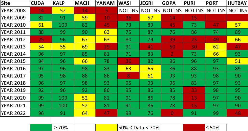
ICORN Data status since 2008